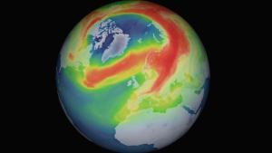


When talking about Omega, weather experts become nervous. Actually, the last letter of the Greek alphabet stands for the end, but meteorologists mean a weather situation that does not like to end. Because it visually resembles the letter, the experts refer to the special constellation of high and low pressure areas as an omega weather situation. And it has it all: Omegalagen are particularly stable and therefore feared. A huge high -pressure area then floats over Central Europe, flanked by two low pressure areas over the North Atlantic and Eastern Europe. In this respect, the omegalage under meteorologists stands for high resistance: the longer it continues, the more extreme the weather becomes.
Now such a weather situation is announced again. At the weekend, atmospheric pressure rises over Central Europe and Scandinavia, very warm air from the south flows to the continent. "It looks very much like an omega situation," says meteorologist Jacqueline Kernn from the German Weather Service in Offenbach, but it is unclear how long the Omega will hold its own this time, which is weakening slightly over Eastern Europe. Because everything depends on whether the flanking low pressure areas support the high in the middle, then the omega will be maintained by the current. "Usually, however, such layers last well and gladly for three weeks," she says. In the hot summer of 2003, the high Michaela settled even longer. At that time, half the country was talking about the notorious Omega, which dominated in the south almost all summer.
The consequences of the current weather conditions can already be seen on the weather apps. Until the next week, the models predict early summer values and a lot of sun, in some places it could even get hot for the first time. Large heat, as it was calculated by some models at the beginning of the week, is unlikely. For this purpose, there is no rain in sight until further notice. This continues to spoil the drought in the east and north, at most at the beginning of the week a small ceiling low could let a few shower and thunderstorms go over the country. After larger amounts of rain, it does not look for the time being.
But why are omegalages so stable? The high in the center of an omegalage is like a bulwark. Meteorologists are among the blocks, also called blockings. The rainy west winds no longer penetrate Europe, the atmosphere is blocked. The high is so stable because there is high air pressure from the ground to the height. Ordinary high -pressure areas, on the other hand, often only form on the ground and are flattened by the advancing west drift after a few days. This leads to the typical change of sun and rain in Central Europe and more moderate temperatures.
No one wants a summer like in 2018
A dipole or re-block (named after the meteorologist Daniel F. Rex) is similarly stable as the omegalage. This constellation also forms a stable high-pressure area in height, also a crowned low pressure area south of it, the so-called cut-off-deep. Under meteorologists, the situation is also described as high over deep. High -pressure areas are also very resistant, which in summer extend from the subtropics into the medium widths. These summer highs can cause blockages in the atmosphere, but are not always one of the blockings.
But what exactly a blocking is, the researchers still disagree about today. There is no uniform definition for blockings and therefore no closed theory. The most important characteristics for atmospheric researchers include their almost stationary location and the resulting blockage of the western current. Some blockage highs are so persistent that they last for several days or even weeks. The longer they last, the worse the effects are. If the situation lasts for weeks or months as in the summer of 2018, the soils dry out and intensify heat waves in addition.
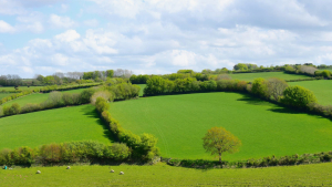
This scenario is currently very worried about foresters, farmers and hydrologists. Nobody wishes to repeat themselves in 2018. Because the current spring is already too dry, 80 liters of rain have so far fallen on average in Germany. That is a good half of the usual quantities until mid -May. For this, the sun had seemed for a long time and a half. It is particularly dry again in Berlin and Brandenburg. In Wiesenburg on the border with Saxony-Anhalt, just ten liters of rain per square meter has been fell since the beginning of March, which is 15 percent. There is now the highest risk of forest fire in this region.
It is also dry in the far west, and even on the wet edge of the Alps there has been too little rain in spring so far. The effects are fatal: In the Rhineland and widespread in the east, the soils are already dust-dry, plants begin to wither. Throughout the East, there is a severe, in some places even extreme drought in the topsoil, according to the drought monitor of the Helmholtz Centre for Environmental Research in Leipzig. The situation is even worse in the deeper soil layers of about 1.80 meters deep: There is even an extraordinary drought in parts of Lower Saxony and in large regions of eastern Germany, the highest of all levels.
So the situation is already tense enough in some places – and the low-rain Omega weather situation has not even started yet. However, meteorologists are concerned not only about the medium term, but above all about the long term, the rough forecast of the weather for the next few months. When the European Meteorological Service ECMWF published its summer forecast at the beginning of May, many experts were not surprised. According to this, the summer in large parts of Europe is expected to be on average one to two degrees warmer than compared to the already warm years from 1993 to 2016, and it is also likely to remain low in rain. If the forecast comes true, the continent would be facing another hot summer.
The signal for a hot and dry summer is exceptionally strong
One can only hope that the forecast turns out to be wrong in the end. Long-term forecasts are associated with considerable uncertainties. In this respect, such calculations should not be taken too seriously. Behind the forecast of the temperature anomalies from June to August are 51 ensemble calculations, which will be carried out at the beginning of May in mainframe computers at the European Centre for Medium-Range Forecasts in Reading near London. From these calculations, the researchers form an average value and compare it with the average value of the years between 1993 and 2016, explains Florian Pappenberger, head of the forecasting department.
Pappenberger confirms that the forecast quality of the seasonal forecast in our latitudes is rather low compared to the tropics. However, there are also areas in Europe in the summer that could be predicted quite well. This includes, above all, South-eastern Europe, where there is a high forecast quality. In northwestern Europe, on the other hand, it is relatively low, he says.
This long -term forecast could therefore be neglected for Central Europe if the signal for a hot and dry summer was not exceptionally strong this year. In addition, the German Weather Service comes to a similar result in its long -term trend. Accordingly, the entire south of Europe would have to prepare for a violent summer with great drought. The American weather service NOAA also calculates a positive deviation.
"The summer calculations already show a very clear signal," says Andreas Brömser, agricultural meteorologist at the German Weather Service. However, one should not now make the mistake of declaring a hot and drought summer. The forecasts are too uncertain for that. Nevertheless, he urges increased caution: In the coming weeks, you should follow the further calculations and as a farmer perhaps already think about how to divide the available water and keep evaporation low.
So far, from agriculture, there has been no major problems, says Brömser. Rapeseed and winter cereals have formed enough deep roots and could well supply water. At most, sugar beet, corn and soy, which were sown at the end of March to April, could run late, and the dry regions of the fertilizers have not yet triggered. Trees and shrubs, on the other hand, would not yet notice much of the drought, explains the agricultural meteorologist.
Now one can only hope that this will remain the case. Fortunately, the upcoming Omega does not seem to hold its ground over Europe as stably as usual. The weather models already indicate its end for the next weekend, heavy showers and thunderstorms are announced. The only problem is that the weather models often underestimate blocking weather conditions. It would therefore not be the first time that the omegalage may simply not end, although the weather models claim otherwise.